-
Pingback: A Guide to Navigating Flood Zones in Real Estate Projects | Flood Risk & Drainage Solutions
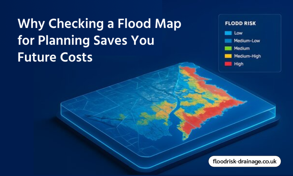
Why Checking a Flood Map for Planning Saves You Future Costs
When analyzing a flooding map for planning purposes, having the right information at the right time is essential. Today, technology has enabled the latest and greatest flood maps that provide information on future flood predictions, and even real-time flood data. As a homeowner, a planner, or an insurance agent, having the knowledge to interpret the flood maps information can help minimize risks and ensure a safer development outcome. Thus, reviewing a reliable flood map for planning also helps streamline planning applications and minimise unexpected costs.
The Value of Flooding Maps in Urban Design
Proper mapping tools assist planners in locating potential flooding incidents, determining the overall flood risk, and developing the development that is in accordance with existing environmental trends. By using flood maps in urban planning, protect infrastructure, and mitigate long-term damage. Flood risk assessment is also enhanced through reviewing Flood Zones and supporting data, which are necessary to ensure that projects undertaken are in conformity with the regulations and facilitate the sustainable growth of urban areas.
- The use of flood maps in urban planning can establish a high-risk flood zoning area before development begins.
- They offer insights into past flood events to inform more informed land-use measures.
- Proper mapping enhances the compliance with regulations and flood risk assessment.
- Understanding flood risk supports resilient infrastructure and sustainable design solutions.
- Always consult experts to easily interpret data and implement effective mitigation measures.
Understanding the Different Types of Flood Maps
Flood maps provide critical information to understand risk levels and make informed decisions for safer, smarter development and planning.
Historical Flood Maps
Historical flood maps show the locations and severity of past floods. They help identify high-risk areas and recurring patterns. With this information, planners and property owners can make more informed decisions about development and investment and gain a better understanding of long-term vulnerability.
Flood Zone Maps
Classify land into low, medium, and high-risk categories based on the probability of flooding. Planning applications, building codes, and insurance requirements all depend on these classifications. They direct where development is appropriate and what safeguards might be required.
Future Flood Projection Maps
These maps estimate potential flooding events over time using climate data and sophisticated modeling. They take into account factors such as rising sea levels and increased precipitation. By helping developers account for long-term environmental changes and potential hazards, these maps promote sustainable planning.
Real-Time Flood Maps
Live data from weather systems, rivers, and monitoring stations is displayed on these flood maps. They are particularly helpful during heavy rain or storms. Emergency services, authorities, and communities use these maps for short-term flood risk management, evacuation planning, and quick decision-making.
The Key Components of a Flooding Map for Planning
To identify potential flooding events and assess overall flood risk, it is crucial to understand the structure of flood maps used in urban planning. These maps include several crucial elements that facilitate efficient flood risk assessments and well-informed development decisions.
Flood Zones
Flood zones, which usually range from high to low risk areas, classify land according to the probability of flooding. Planners can use these classifications to assess where development is appropriate and what mitigation strategies might be needed. Clearly defined zones strengthen safer land-use planning and flood risk assessments.
Water Depth
Data on water depth indicate the potential depth of floodwaters during particular flooding events. Moreover, this data is essential for evaluating possible infrastructure and building damage. Developers can create structures that reduce the risk of flooding and increase long-term resilience by understanding anticipated water levels.
Flow Velocity
The rate at which floodwaters traverse a site is indicated by flow velocity. Water flowing more quickly raises the risk of structural damage and safety issues. Moreover, to effectively manage flood risk, authorities can identify hazardous areas and implement targeted measures by incorporating velocity data into urban flooding maps.
The Top Tips to Interpret Flooding Maps Easily
By identifying key indicators and risk classes, property owners and planners would be better able to evaluate potential flood risk and take the necessary measures to ensure that future flood effects do not adversely affect investments, infrastructure, and immediate communities.
Determine Flood Zones First
Finding the clearly marked flood zones is the first step in examining flooding maps for urban planning. These zones all of which range from high to low probability areas, are usually color-coded to represent varying degrees of flood risk. Determining development suitability, insurance implications, and whether additional research or mitigation measures are needed all depend on knowing which zone a property is in.
Examine Past Flooding Incidents
You can determine the frequency and severity of flooding in an area by reviewing records of past flooding events. Moreover, better planning decisions are supported by the useful context that historical data offers. Good controls, resilient design techniques, and a more thorough assessment before moving forward with development may be necessary in areas with a history of flooding.
Analyse Water Depth and Flow Velocity
Indicators of water depth and flow velocity indicate how deep the floodwaters may reach and how quickly they may travel through a site. These aspects play an important role in the possible structural and safety hazards. So, close flood risk assessments of this information helps planners create suitable foundation levels, drainage systems, and protective measures to minimize overall flood risk.
Use Official and Updated Mapping Sources
Always rely on authoritative data and use only the regularly updated flood maps in urban planning to ensure that all the decisions are based on best data. Government-backed resources provide the most reliable information on risk classifications and future projections. So, by using trusted sources it minimises uncertainty and strengthens planning applications and long-term development strategies.
Combine Maps with Flood Risk Assessments
Using flood maps alone should not be considered. A professional flood risk assessment includes site-specific analysis, drainage capacity assessment, topographic analysis and environmental assessment. Climate change, increased rainfall and rising water levels can significantly alter long-term flood risk. Integrating the two tools will help better understand potential hazards and make more responsible planning decisions.
Final Words
In conclusion, flood maps are crucial for ensuring safe and sound development because they enable early identification of flood zones and all areas vulnerable to water damage. Developers can quickly improve flood risk assessments and avoid expensive setbacks by gaining access to the precise mapping data. The availability of official government flood map resources ensures up-to-date information that enables the best possible decisions and encourages sustainable and long-term planning in flood-prone areas.